


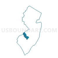
Pennsauken township voting district 27, Camden County, New Jersey
About
Outline

Summary
| Unique Area Identifier | 617841 |
| Name | Pennsauken township voting district 27 |
| County | Camden County |
| State | New Jersey |
| Area (square miles) | 0.69 |
| Land Area (square miles) | 0.59 |
| Water Area (square miles) | 0.10 |
| % of Land Area | 85.48 |
| % of Water Area | 14.52 |
| Latitude of the Internal Point | 39.92968210 |
| Longtitude of the Internal Point | -75.07582030 |
Maps


Graphs
Select a template below for downloading or customizing gragh for Pennsauken township voting district 27, Camden County, New Jersey


Neighbors
Neighoring Voting District (by Name) Neighboring Voting District on the Map
- Camden city ward 2 voting district 1, Camden County, NJ
- Camden city ward 2 voting district 3, Camden County, NJ
- Cherry Hill township voting district 6, Camden County, NJ
- Cherry Hill township voting district 8, Camden County, NJ
- Collingswood borough voting district 12, Camden County, NJ
- Collingswood borough voting district 5, Camden County, NJ
- Collingswood borough voting district 6, Camden County, NJ
- Collingswood borough voting district 9, Camden County, NJ
- Pennsauken township voting district 25, Camden County, NJ
- Pennsauken township voting district 26, Camden County, NJ
Top 10 Neighboring County Subdivision (by Population) Neighboring County Subdivision on the Map
- Camden city, Camden County, NJ (77,344)
- Cherry Hill township, Camden County, NJ (71,045)
- Pennsauken township, Camden County, NJ (35,885)
- Collingswood borough, Camden County, NJ (13,926)
Top 10 Neighboring Place (by Population) Neighboring Place on the Map
Top 10 Neighboring Unified School District (by Population) Neighboring Unified School District on the Map
- Camden City School District, NJ (77,344)
- Cherry Hill Township School District, NJ (71,045)
- Pennsauken Township School District, NJ (35,885)
- Collingswood Borough School District, NJ (13,926)
Top 10 Neighboring State Legislative District Lower Chamber (by Population) Neighboring State Legislative District Lower Chamber on the Map
- General Assembly District 6, NJ (222,700)
- General Assembly District 7, NJ (219,914)
- General Assembly District 5, NJ (210,162)
Top 10 Neighboring State Legislative District Upper Chamber (by Population) Neighboring State Legislative District Upper Chamber on the Map
- State Senate District 6, NJ (222,700)
- State Senate District 7, NJ (219,914)
- State Senate District 5, NJ (210,162)
Top 10 Neighboring 111th Congressional District (by Population) Neighboring 111th Congressional District on the Map
Top 10 Neighboring Census Tract (by Population) Neighboring Census Tract on the Map
- Census Tract 6032, Camden County, NJ (7,055)
- Census Tract 6014, Camden County, NJ (4,494)
- Census Tract 6042, Camden County, NJ (3,387)
- Census Tract 6026.01, Camden County, NJ (2,684)
- Census Tract 6106, Camden County, NJ (1,254)